
THE POWER OF GEOGRAPHY: Ten Maps That Reveal the Future of Our World
by Tim Marshall, 2021
This book is a masterpiece on geopolitics. The central idea of this book is that the world is entering a new age of great-power rivalry in which numerous actors, even minor players, are increasingly playing an important role.
The big eye-opener for me was the complex politics that’s playing out in the middle east: Turkey has an acrimonious relationship with pretty much all countries in the region plus they have a love-hate relationship with Russia; Iran is actively working on building a corridor of influence all the way westward to Egypt; with decreasing importance of oil Saudi Arabia is trying to make a major pivot – they have befriended Israel to buy iron dome technology and they are investing heavily in technology. Middle East’s politics is complex where your enemy’s enemy might be your enemy as well.
Below are my notes –
AUSTRALIA
*Australia’s size and location are both a strength and weakness. They protect it from invasion but also held back its political development.
*As a continent it experiences extreme diversity in its climate and topography, from deserts to tropical forests to snow-capped mountains. But the majority of it is taken up by what is known as the Outback, covering about 70 per cent of Australia, much of it uninhabitable.
*Almost 50 per cent of the people live in just three cities – Sydney, Melbourne and Brisbane.
*Its wool, lamb, beef, wheat and wine industries remain world leaders, it holds a quarter of the world’s uranium reserves, the largest zinc and lead deposits, it is a major producer of tungsten and gold, has healthy deposits of silver and it is still a major producer of coal.
*The Malacca Strait is the shortest route from the Indian Ocean to the Pacific. It sees 80,000 vessels pass through it each year, carrying about a third of the world’s traded goods including 80 per cent of the oil heading for Northeast Asia
*China is by far its biggest trading partner, although levels of investment fluctuate sometimes in line with those of diplomatic warmth. China buys almost a third of Australia’s exported farm produce, including 18 per cent of its beef exports and half its barley. It is also a major market for Australia’s iron ore, gas, coal and gold.
IRAN
*Iran is defined by two geographic features: its mountains, which form a ring of crust on most of its borders, and the mostly flat salt deserts of the interior, along which run lower-range hills roughly parallel to each other. The mountains make Iran a fortress.
*Almost all Iranians live in the mountains. Because they are difficult to traverse, populated mountain regions tend to develop distinct cultures. Ethnic groups cling to their identities and resist absorption, making it harder for the modern state to foster a sense of national unity.
*Lack of water is one of several factors which have held Iran back economically. About one-tenth of the land is cultivated, a mere third of which is irrigated.
*Iran holds the world’s fourth-largest reserves of oil and second-largest of gas
*Strait of Hormuz: one-fifth of global oil supplies pass through it, closure would mean a world of pain. It would also cause massive disruption to oil and gas shipments from Iraq, Kuwait, Saudi Arabia and the UAE, leading to a huge rise in energy prices and potentially a global recession.
*When Tehran feels under pressure, especially when its oil exports are threatened, it uses a variation of a warning issued in 2018: ‘We will make the enemy understand that either everyone can use the Strait of Hormuz or no one.’
SAUDI ARABIA
*Saudi Arabia is the world’s largest country without a river and the interior is dominated by two vast deserts. It is the largest continuous area of sand in the world, covering a region bigger than France.
*The Saudis view Syria as an Iranian land bridge linking Tehran, via Baghdad and Damascus, to the Iranian-funded Shia Hezbollah militia in Beirut.
*Qatar and Saudi Arabia have been at odds since the mid 1990s, especially since Qatar set up Al Jazeera TV, which the Saudis say is hostile to them.
*The Saudis have long opposed the Brotherhood as it seeks to topple royal dynasties. In 2013 Riyadh supported the military coup in Egypt which deposed the elected Muslim Brotherhood leader Mohamed Morsi and replaced him with General Sisi.
*Saudi’s Vision 2030 accepts that the economy must be diversified, with the focus on technology and the service sectors. Budget projections for the next few years envisage a steady draining of foreign reserves and the sovereign wealth fund.
*The state pays for an exceptionally generous welfare system. Rapidly declining income from oil and gas means that this is unsustainable; but without welfare, and with high unemployment, unrest is all but certain.
*Saudi’s domestic oil consumption has been on an upward trend. The country burns about a quarter of the oil it produces, and that burns through a huge part of the government’s income. Petrol and electricity are supplied to the public at a fraction of even the lowest prices in most developed countries.
*Saudi Arabia is the sixth-largest consumer of oil in the world and air conditioners use 70 per cent of Saudi Arabia’s electricity.
*The kingdom has the largest desalination operation in the world, which successfully produces the majority of its domestic needs. The massive desalination plants require large amounts of electricity, which comes from oil.
*Saudi Arabia owns 5 per cent of Tesla, and has invested heavily in General Motors’ push towards electric cars.
*China has sold the kingdom intermediate-range ballistic missiles, its oil imports have grown rapidly in the past few years, and Saudi Arabia has signed one of the twelve 5G contracts Huawei has won in the region.
GREECE
*Greece includes more than 6,000 islands. Nowhere in Greece is more than 100 kilometres from water.
*Under international maritime laws a country has 200 nautical miles of Exclusive Economic Zone (EEZ) from its coastline.
*The waters around islands such as Crete, Rhodes and Lesbos belong to Greece, meaning that most of the Aegean is Greek territory – a fact that Turkey does not accept.
*Erdoğan has appeared in an official photograph of a 2019 visit to Istanbul’s National Defence University standing in front of a map showing half of the Aegean as belonging to Turkey.
*The term ‘Thucydides Trap’, originally about the growth of Athenian power and the fear that this caused in Sparta, now refers to the rise of China and the emotions this evokes in the US
*Four-fifths of Greece is mountainous, characterized by jagged peaks and spectacular deep gorges.
*There is limited scope for large-scale farming is why only about 4 per cent of GDP comes from agriculture; Greece imports significantly more food than it exports.
*The two world wars cost Greece 9,500 men but extended its land by 70 per cent.
*Greece, like Italy, believes it is being asked to be Europe’s border police, but without EU funding. Both fear they will be hosting refugees in squalid camps for years to come.
*The discovery of potentially huge reserves of natural gas in the eastern Mediterranean has complicated what was already a potential source of conflict between Greece and Turkey. Gas fields have been found off Egypt, Israel, Cyprus and Greece. Russia is watching the whole scene nervously as its dominant position supplying natural gas to Europe comes under threat.
TURKEY
*Around 97 per cent of Turkey’s land is in Asia, and most of it consists of Anatolia.
*The Bessarabian Gap is the lowland between where the Carpathian Mountains finish and the Black Sea begins. If you hold the Gap, you control the southern east–west route.
*Ottoman’s defeat by the Habsburg Empire at the gates of Vienna in 1683 marked the beginning of a long but steady decline, leading to the collapse of their empire in 1923.
*The Turks do not accept the treaty which then left Greece in control of most of the islands off the Turkish coast, and the loss of Kurdish and Arab territory in Syria still rankles with some.
*Within Turkish military circles, supporters of the concept of ‘Mavi Vatan’ – the Blue Homeland – are usually sceptical of their country’s membership of NATO and believe it to be an American plot (helped by Greece) to prevent Turkey from rising to its rightful place in the world. The Blue Homeland idea encompasses a world view in which Turkey will dominate the three seas around it – the Black Sea, the Aegean and the eastern Mediterranean.
*It’s thought that the name Istanbul comes from Greek speakers referring to visits as eis ten polin – ‘into the city’ – which transmuted into Istanbul.
*By 2020 Turkey had fallen out with Syria, Egypt, Saudi Arabia, the UAE, Kuwait, Israel, Iran, Armenia, Greece, Cyprus and France and had irritated all of its NATO allies by buying the S-400 missile defence system from NATO’s great rival – Russia.
*More than 50 per cent of Turkey’s 85 million population live in the greater Istanbul area or along the narrow coastal plains of the Black Sea and Mediterranean
*Around 90 per cent of the Euphrates River and 45 per cent of the Tigris River originate in the Anatolian highlands. The Euphrates flows into Syria and Iraq, and runs almost parallel with the Tigris before they merge in southern Iraq. The fertile land between them gave birth to the name ‘Mesopotamia’, or ‘between two rivers’.
*It’s often said that the Kurds are the largest nation without a state.
*Seventy per cent of Turkish military equipment is now built domestically, and the country has become the world’s fourteenth-largest arms exporter, although it’s worth noting that orders from NATO allies are few and far between. Its big-ticket project is the TF-X, intended as a state-of-the-art fighter jet to replace the F-16 by 2030.
*Turkey is expanding its capacity and now builds tanks, armoured vehicles, infantry landing craft, drones, sniper rifles, submarines, frigates, and in 2020 launched its first light aircraft carrier, which is capable of transporting helicopter gunships and armed drones.
SAHEL
*The word Sahel derives from the Arabic for shore, or coast, which is how early travellers thought of the area, having made the voyage across the world’s largest dry desert.
*It also forms a 6,000-kilometre-long corridor across Africa, connecting the Red Sea to the Atlantic.
*For thousands of years, periods of extreme dry or wet weather have caused the vast spaces of the Sahara to expand and contract, and thus have shaped the Sahel and its peoples – where they live, what they do and how they behave.
*Much of the Sahel fell under French control at the infamous Berlin conference of 1884–5 (where Europeans carved up Africa.
*French have thousands of expats in the Sahel states, including Niger, home to the uranium mines which help fuel the French nuclear industry and keep the lights on in French houses.
*In the last four decades of the twentieth century lake Chad shrank by 90 per cent causing a huge loss of fish, jobs and income among the millions of people in Chad and neighbouring countries who rely on its waters.
*Across the Sahel region 30 million people face ‘food insecurity’, of whom, according to the UN’s Food and Agriculture Organization (FAO), about 10 million are at extreme risk of hunger.
*Africa has the fastest demographic rate in the world. Between now and 2050 the population of the continent is expected to double from about 1.2 billion to 2.4 billion.
*Niger is the world’s fourth-largest producer of uranium but the government is locked into an unequal relationship with the French state-owned company Areva.
*Beijing is expanding military footprint in the Sahel. In 2015 China passed a law allowing the overseas deployment of the People’s Liberation Army. China persuaded Burkina Faso to end its recognition of Taiwan. In 2017 it opened its first foreign naval base – at Djibouti.
*China has funded an electric railway line from Djibouti to Ethiopia, and Chinese companies are busy building rail links connecting ports in Guinea and Senegal to landlocked Mali. Several hundred thousand Chinese workers are said to be involved in African Belt and Road activities.
ETHIOPIA
*Tourism accounts for almost 10 per cent of the country’s GDP, with close to 1 million people a year venturing into an epic landscape of high mountains, tropical forests, burning deserts, nine World Heritage sites
*Water defines Ethiopia’s geopolitical position and importance. Fresh water is its main strength, and saltwater one of its weaknesses (landlocked). It has twelve large lakes and nine major rivers, most of which supply its neighbours, giving Ethiopia enormous political leverage over them.
*After water, the most defining geographical element about Ethiopia is that a rift runs through it – the East African Rift system. The mountains and valleys it created have long divided the country, and its leaders have always struggled to build the bridges, both literal and symbolic, necessary to bring it together. Most of the coffee plantations, which are the biggest foreign-exchange earner, are situated there.
*Ethiopia is the leading military power in the wider Horn of Africa area.
*Ethiopia sits at the centre of one of the most troubled regions in the world. In this century Sudan, South Sudan, Somalia, Ethiopia and Eritrea have all experienced civil wars, while Kenya has been rocked by wide-scale ethnic clashes and has suffered numerous terrorist attacks by the Somali-based Al-Shabab group.
*Ethiopia was, famously, never colonized but, having built its own empire, it has similar problems within its borders. Ethiopia has nine major ethnic groups among its population. There are nine administrative areas and two self-governing cities, all based on ethnicity.
*It’s the most populous landlocked country in the world.
*Approximately 90 per cent of Ethiopia’s imports and exports travel by sea, and almost all cargo goes via the deep-water port of Djibouti.
*Turkey has been expanding its economic footprint in Ethiopia and is now the second-biggest investor in the country behind China.
*Biggest bone of contention between Ethiopia and Egypt is GERD (Grand Ethiopian Renaissance Dam). It is Africa’s largest hydroelectric power plant being built on Nile.
*For the Egyptians the building of the GERD is an existential matter – this is one of the clearest examples of a country being a prisoner of its geography.
*Egypt is mostly desert, and so 95 per cent of its 104-million-strong population live along the Nile’s banks and delta. Egypt has said it will use ‘all available means’ to defend its interests which has led many analysts to speculate that a major ‘water war’ was on the cards between Egypt and Ethiopia.
SPAIN
*Spain is a vast fortress. From the Mediterranean Sea and the Atlantic Ocean, narrow coastal plains quickly bump up against great walls of mountains and the entire central region is a plateau with its own high ranges and deep valleys. Spain one of the most mountainous countries of Europe.
*Spain’s mountainous terrain and size have always hampered trade links and strong political control, and ensured that the different regions retain strong cultural and linguistic identities. Such are the complexities and passions of these differences that the Spanish national anthem does not have lyrics as no one can agree on what they should be.
*Even at the height of Spain’s powers, its internal geography limited its wealth creation and political unity.
*Arabic in particular left its mark on Spain: more Spanish words are taken from Arabic than any other language apart from Latin. The very name Gibraltar comes from Tariq ibn Ziyad: the rock became known as ‘Jabal Tariq’ (‘Tariq mountain’).
*General Franco imposed an economic system known as autarky – self-sufficiency, state control of prices, and limited trade with other countries. It had a devastating effect. The 1940s became known as ‘Los Años de Hambre’ – the years of hunger.
*Basque Country spans two states, but many Basques consider it still to be one nation called ‘Euskal Herria’. Its language, Euskara, predates the Indo-European tongues of the rest of Europe and is unrelated to any of them. For example, ‘I live in Bilbao’ translates as ‘Ni Bilbon bizi naiz’ and is constructed as ‘I Bilbao in to live am.’
*Catalonia is the wealthiest region in the country, a fact which has played a role in the recent upheavals. Catalonia became wealthy through its textile industry, but now has a diversified economy including heavy industry and tourism.
*Spain is one of Europe’s leaders in renewable energy, especially solar and wind.
SPACE
*Everett Dolman created a maxim which echoes Halford Mackinder’s famous 1904 ‘Heartland’ geopolitical theory about control of the world, ‘Who rules East Europe commands the Heartland.’ Dolman’s version is: ‘Who controls low Earth orbit controls near-Earth space. Who controls near-Earth space dominates Terra. Who dominates Terra determines the destiny of humankind.’
*For the next few decades, the most important space exploration is Earth Space, particularly Low Earth Orbit (LEO). This is where our communication – and increasingly our military – satellites are being placed.
*More energy is required to get from the Earth’s surface to the Moon than from low Earth orbit to Mars.
*There are five ‘libration’ points near the Earth. These are places where the gravitational effects of the Earth and Moon cancel each other out, allowing objects stationed there to remain in position without having to use fuel.
*Military concept of ‘full-spectrum dominance’ now includes space, from low orbit to the Moon, and eventually beyond.
*Russia, China, the USA, India and Israel have developed ‘satellite-killer’ systems – specialist space weapons that destroy satellites.
*There are currently 3,000 dead satellites and 34,000 pieces of space junk at least 10 cm in size, and many smaller, orbiting the planet.
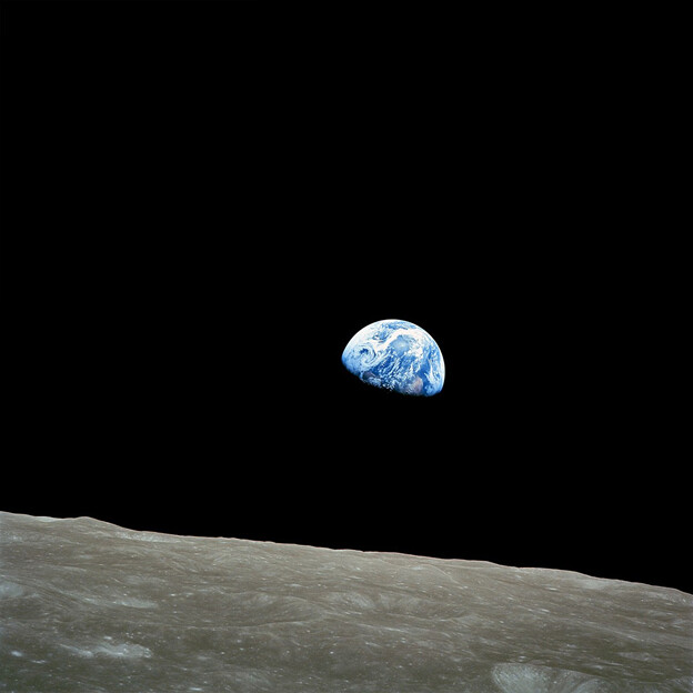
*Astronaut William Anders had taken the awe-inspiring ‘Earthrise’ photograph showing the surface of the Moon with the Earth in the background. It may be the most famous photograph ever taken and is credited with massive influence on the environmental movement.
| Subscribe To Our Free Newsletter |
